
Learn
Glossary
Expand To See Full Text
GLOSSARY
| Condensation | The process by which water vapor in the air is changed into liquid water; responsible for cloud formation |
| Evaporation | Water changing from liquid to vapor ~90% of atmospheric moisture comes from oceans, seas, lakes, and rivers; ~10% from plant transpiration. |
| Evapotranspiration | Evaporation from land surfaces plus transpiration from plants. |
| Freshwater Storage | Surface freshwater in streams, ponds, lakes, reservoirs, and wetlands; typically <1,000 mg/L dissolved solids. |
| Groundwater Discharge | Groundwater emerging at the surface and flowing into stream beds. |
| Infiltration | Downward movement of water from the surface into soil or porous rock. |
| Precipitation | Water released from clouds as rain, freezing rain, sleet, snow, or hail; primary delivery of atmospheric water to Earth. |
| Saturated Water Content | When soil pore space is completely filled with water; new rain has nowhere to go, increasing flood risk. |
| Snowmelt Runoff to Streams | Surface runoff from snow and ice into strams and other surface waters; a major component of global water movement. |
| Soil Water Content | The fraction of a soil’s volume that is water (e.g., 25% means 1 m³ of soil contains 0.25 m³ of water). |
| Solar Radiation | Global solar radiation (direct + diffuse) in the 400–1100 nm range; measured in W m−2. |
| Springs | Where a hillside, valley bottom, or excavation intersects flowing groundwater at/below the water table; ranges from intermittent seeps to large, continuous flows. |
| Streamflow | The movement and amount of water flowing in a natural channel (e.g., a river |
| Sublimation | Water changing directly from solid (ice/snow) to vapor, bypassing liquid; common in arid climates. |
| Surface Runoff | River water originating directly from land-surface runoff (in addition to direct precipitation and groundwater inputs). |
| Sublimation | Evaporation of water from plant leaves; roughly 10% of atmospheric moisture (with ~90% from water bodies). |
| Transpiration | Evaporation of water from plant leaves; roughly 10% of atmospheric moisture (with ~90% from water bodies). |
| Water in the Atmosphere | Water stored as vapor (clouds, humidity); ~0.001% of Earth’s total water volume at any time. |
| Water Storage in Ice or Snow | Freshwater stored in glaciers, icecaps/fields, and snowfields; can remain for long periods. |
| Water Storage in Oceans | Saline water in oceans and inland seas; ~96.5% of Earth’s water is stored in oceans, which also supply ~90% of evaporated water to the cycle. |
| Water Vapor | Vapor Pressure Deficit (VPD) is the difference between moisture in the air and how much it can hold when saturated; when saturated, water condenses into clouds, dew, or films on surfaces. |
Resources
Interactive Water Science Website Tools
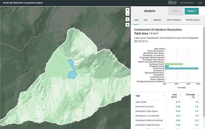
Model My Watershed
A National Science Foundation, funded project with a Water Balance module,
View/Modify my Watershed tools, and a real-time data map for hydrologic analysis.
Michigan Watershed Program
Interactive educational site allowing users to explore water use, pollution impacts,
and their effects on local groundwater and ecosystems.

WEPP Online Watershed Simulation
An online erosion and water flow simulator developed by Purdue University that models
how soil, slope, and rainfall influence watershed behavior.
Water Science Resources
USFS Natural Inquirer
A recent issue of USFS Natural Inquirer (a middle school science education journal) is on freshwater and contains 7 articles focusing on the topic. Some articles include research on drinking water, watersheds, groundwater, freshwater mussels, and chemicals in urban waterways. The journal can be viewed and ordered here.
Data Driven Hydrology Education
Links to posters and abstracts presented at Consortium of Universities for the Advancement of Hydrologic Science, Inc. (CUAHSI) virtual workshop.
Resources from the CUAHSI virtual workshop include:
- Teaching Isotope Hydrograph Separation with Real Data. A. Jefferson, Department of Geology, Kent State University and D. Dees, Faculty Professional Development Center and School of Foundations, Leadership and Administration, Kent State University.
- Combining Hands-on Field Experience with Data-Driven Hydrology Education Tools. J. Williams, B. Forsythe, M. Carroll, and S. Brantley, Earth & Environmental Systems Institute, Penn State University, and E. Ruocchio and Y. Pickering, Earth Systems Science Faculty Mentors, State College Area High School.
- An Excel Based Module to Explore the Major Drivers of Snowmelt During Rain-On-Snow Flooding Events. W. Currier, N. Wayand, & J. Lundquist University of Washington, Mountain Hydrology Research, Civil and Environmental Engineering.
- Estimating Trends in Long-Term Evapotranspiration in the Red River of the North Basin, Minnesota and North Dakota. P. Gerla, H. Hamm School of Geology and Geological Engineering, University of North Dakota.
USGS Water Science School
The USGS site is packed full of information for everyone, including educators. It features an interactive Water Cycle Diagram that can be altered for beginner to advanced student levels. There are detailed pages that include expanded definitions and descriptions of different components and phases of the water cycle.
US EPA Kids Pages
Focused on the Water Cycle and Drinking Water. Multiple pages with information, interactive games, an animation (Thirstin’s Water Cycle) and more. Includes a list of additional educational resources.
Woods Hole Oceanographic Institute
A well-illustrated page with clickable definitions for components of the water cycle.
Edumedia Water Cycle
A site specializing in interactive simulations for science teaching. Lots of great resources for purchase.
Earthguide Animated Diagram
This project is part of the Geosciences Research Division of the Scripps Institution of Oceanography.
APEC Systems
Good overall description of the water cycle by a water treatment company. Includes a thorough list of links to other sites for students and teachers.
Utah Division of Water Resources
Educational page for kids and adults. Includes general information, games and teacher resources, much of which is specific to Utah and the region.
Project Wet
An interactive diagram of the water cycle. Users click through the different components of the cycle.
USGS Water Data Discovery
The National Water Information System (NWIS) is the Nation’s principal repository of water resources data. Data includes two categories: Water Now (realtime reporting of different water parameters) and Water Then (reports and summaries of past water use, yield, and more).
Beyond Penguins and Polar Bears
An online magazine for elementary school teachers focused on the Polar Regions of Earth from a science perspective. Includes many articles including water cycle information. Published by Ohio State University.